this post was submitted on 16 Apr 2024
575 points (86.8% liked)
Funny
7009 readers
1447 users here now
General rules:
- Be kind.
- All posts must make an attempt to be funny.
- Obey the general sh.itjust.works instance rules.
- No politics or political figures. There are plenty of other politics communities to choose from.
- Don't post anything grotesque or potentially illegal. Examples include pornography, gore, animal cruelty, inappropriate jokes involving kids, etc.
Exceptions may be made at the discretion of the mods.
founded 2 years ago
MODERATORS
you are viewing a single comment's thread
view the rest of the comments
view the rest of the comments
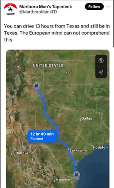
Your geography lesson for today is (Google) mapping a route from Brest to Menton (France) and compare it to the route posted by OP.
Your history lesson for today is looking up when Canada became the 51st state....and realize I was being sarcastic.
But that's crossing a country. Texas is a state. Going from San Diego to Portland, Maine is ~46 hours, and that's probably not the longest route. There's also Alaska and Hawaii (no direct roads to the contiguous 48 states), and Florida, that's just a pretty long route off the top of my head.
Your geography lesson for today is to map 2 routes across the EU and compare them to your statement.
Lol, I always forget how much random stuff France owns across the globe.
But here's an overlay of the EU on the contiguous 48 US states from Reddit (doesn't include Alaska, which is half as big as the whole US). That even gives the EU UK, which is no longer a member state. Alaska is really really big (like more than half the size of the lower 48 states).
As next lesson you’re going to learn about the failings of the Mercator projection - stay with me you’re going to love this!
While Alaska is pretty massive it is not as big as you think it is. Follow this link to the website that Redditor used to create the visual and drag Alaska onto the rest of the US: https://www.thetruesize.com/#?borders=1~!MTYxNTY4MzI.ODIwNzY1OAMTA0MzY2ODQ(MzUyODQ4MQ~!CONTIGUOUS_USMTAwMjQwNzU.MjUwMjM1MTc(MTc1)Mg~!INNTI2NDA1MQ.Nzg2MzQyMQ)MQ~!CNOTkyMTY5Nw.NzMxNDcwNQ(MjI1)MA~!US-AK*MzU2MjMwMg.Mjg0OTg3OTk)Mw
Next drag Greenland onto Africa and vice versa, then both onto the US. Amazing isn’t it?
This is awesome!!