For the lazy
Geography is just physics slowed down, with a couple of trees stuck in it. - Terry Pratchett

Notice Board
Geography is the study of places and the relationships between people and their environments. Geographers explore both the physical properties of Earth’s surface and the human societies spread across it. They also examine how human culture interacts with the natural environment and the way that locations and places can have an impact on people. Geography seeks to understand where things are found, why they are there, and how they develop and change over time. Read more...
Rules
Quick Links
-
Links
News & Publications
Resources

Find us on Reddit!


For the lazy
TL;DR: Without any International body recognizing it to be valid, the U.S.A. decided to claim additional chunks of ocean/continental shelf as its own.
relevant bits:
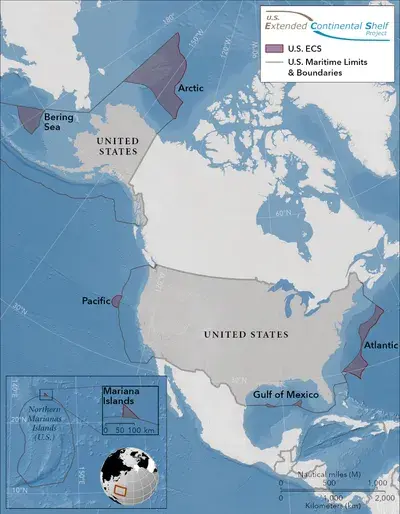
As many as 75 countries have defined their Extended Continental Shelf (ECS) limits, which refers to the portion of the continental shelf beyond 200 nautical miles (230 miles) from the coast. Until now, the US has not done this.
On December 19, 2023, the US State Department announced new geographic coordinates defining what they claim to be their ECS area.
Since 2003, US authorities have been collaborating with the NOAA, the US Geological Survey, and 12 other agencies to gather geological data to define the outer limits of their ECS.
In light of this work, the US now claims ECS in seven offshore areas: the Arctic, Atlantic (east coast), Bering Sea, Pacific (west coast), Mariana Islands, and two areas in the Gulf of Mexico. In total, this consumes an area that's 1 million square kilometers (more than 386,000 square miles) in size.
The legality of all this is a bit hazy, Treadwell explains in a post for the Wilson Center. To make the definition official, the US has to submit data and reports to the United Nations Convention on Law of the Sea (UNCLOS). However, the US has not ratified UNCLOS due to complex political disagreements (the agreement has been ratified by 168 states and the European Union).
I hope Canada at least pretends to push back.
On what grounds?
On the grounds that a big and valuable chunk of territory that is currently being shared shows signs of being unilaterally fenced off. I'm not suggesting that Canada has a better claim, but it's important for procedures to be followed.
Edit: I wanted to get my wording right, so I went back to the article:
The legality of all this is a bit hazy, Treadwell explains in a post for the Wilson Center. To make the definition official, the US has to submit data and reports to the United Nations Convention on Law of the Sea (UNCLOS). However, the US has not ratified UNCLOS due to complex political disagreements (the agreement has been ratified by 168 states and the European Union).
This leaves some uncertainty around how the proposition will be accepted under international law.